Saturday, December 23, 2006
Interesting Weather Due For Christmas
The National Weather Service has issued a Special Weather Statement for Western North Carolina ahead of
a system due here early Christmas Morning, which will begin as rain, and likely end as snow for much of the area, details below. Go to the GSP Page for continued updates.
a system due here early Christmas Morning, which will begin as rain, and likely end as snow for much of the area, details below. Go to the GSP Page for continued updates.
...ACTIVE HOLIDAY WEATHER...

A LOW PRESSURE SYSTEM WILL DEVELOP IN THE GULF OF MEXICO
SUNDAY...AND WILL MOVE NORTHEAST TO THE GULF COAST SUNDAY
NIGHT...SPREADING MOISTURE TO THE SOUTHERN APPALACHIANS. RAIN
WILL DEVELOP SUNDAY NIGHT ACROSS THE WESTERN CAROLINAS AND
NORTHEAST GEORGIA...CONTINUING THROUGH MONDAY. AS A COLD FRONT
ASSOCIATED WITH THE LOW PRESSURE SYSTEM CROSSES THE AREA LATE
MONDAY AFTERNOON...RAIN WILL DIMINISH EAST OF THE MOUNTAINS. RAIN
WILL CHANGE TO SNOW IN THE MOUNTAINS LATE MONDAY NIGHT. SNOW WILL
FALL IN THE MOUNTAINS THROUGH MUCH OF TUESDAY...BECOMING CONFINED
TO THE NORTH CAROLINA BORDER WITH TENNESSEE BEFORE ENDING TUESDAY
EVENING.

THIS SYSTEM HAS THE POTENTIAL TO PRODUCE UP TO TWO AND ONE HALF
INCHES OF RAIN ACROSS THE PIEDMONT OF UPSTATE OF SOUTH
CAROLINA AND THE CHARLOTTE METROPOLITAN AREA...AS WELL AS THE
MOUNTAINS OF NORTHEAST GEORGIA. UP TO TWO INCHES OF RAINFALL ARE
EXPECTED IN THE MOUNTAINS OF SOUTH CAROLINA. OTHER AREAS OF THE
WESTERN CAROLINAS AND NORTHEAST GEORGIA CAN EXPECT ONE AND ONE
HALF INCHES OF RAINFALL. UNLIKE THE LAST RAIN EVENT...THIS RAIN
EVENT WILL ARRIVE WITH SOIL MOISTURE AND STREAM LEVELS ALREADY
ELEVATED.

SNOW ACCUMULATIONS OF OVER FOUR INCHES ARE POSSIBLE IN THE NORTH
CAROLINA MOUNTAINS LATE MONDAY NIGHT AND TUESDAY...ESPECIALLY IN
COUNTIES ADJACENT TO THE TENNESSEE BORDER.

AHEAD OF THE LOW PRESSURE SYSTEM...SOUTHERLY WINDS OF 40 TO 50 MPH
ARE POSSIBLE ABOVE 3000 FEET IN THE MOUNTAINS ON MONDAY. ON
TUESDAY...NORTHWEST WINDS OF 25 TO 35 MPH WITH GUSTS TO 45 MPH
ARE EXPECTED ACROSS THE NORTH CAROLINA MOUNTAINS AND FOOTHILLS.

TRAVELERS SHOULD KEEP INFORMED OF THIS DEVELOPING WEATHER SYSTEM.
STAY TUNED TO THE MEDIA OR NOAA WEATHER RADIO FOR THE LATEST INFORMATION.
Friday, December 22, 2006
Heavy Rain Event for WNC
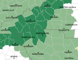
The Counties in Dark Green are under a Flood Watch:
There is also another system expected to hit the mountains on Christmas Day, this will likely be a mixed rain, sleet, ice, and snow event depending on your elevation. I will post more on that system as the forecasts stabilize.FLOOD WATCH
NATIONAL WEATHER SERVICE GREENVILLE-SPARTANBURG SC
350 AM EST FRI DEC 22 2006
...HEAVY RAINFALL EXPECTED ACROSS PORTIONS OF THE WESTERN
CAROLINAS AND NORTHEAST GEORGIA TODAY...
A VIGOROUS UPPER LEVEL STORM SYSTEM WILL PASS NORTHWEST OF THE
REGION TODAY...WHILE ABUNDANT MOISTURE CONTINUES TO STREAM
NORTHWARD FROM THE GULF OF MEXICO AND THE ATLANTIC. THE
COMBINATION OF THESE FACTORS WILL LEAD TO THE POTENTIAL FOR
HEAVY...AND PERHAPS EXCESSIVE RAINFALL ACROSS PORTIONS OF THE AREA
TODAY. THE MOST LIKELY AREAS FOR EXCESSIVE RAINFALL WILL BE ALONG
AND NEAR THE SOUTHEAST EXPOSURE OF THE BLUE RIDGE ESCARPMENT.
Thursday, December 21, 2006
Heavy Rain Expected For WNC
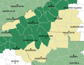
The counties in dark green are under a Flood Watch for Friday, the first full day of Winter.
National Weather Service GSP Page
Friday, September 01, 2006
Topical Tropical Updates
-
-
Hurricane City
-
<>http://www.hurricanecity.com<>
Saturday, May 27, 2006
First Pacific TD Forms

Monday, May 22, 2006
NOAA 2006 Tropical Season Predictions
Batten up the hatches, NOAA predicts a busy Hurricane Season .
13 to 16 Named Storms of at least Tropical Storm strength.
8 to 10 Hurricanes Categories I and II strength.
4 to 6 Major Hurricanes Categories III, IV, and/or V strength.
Compare this to last years record-breaking season:
28 Named Storms
15 Hurricanes
7 Major Hurricanes
May 21 to 27 is Hurricane Prepardness Week.....Don't say you weren't warned!
Monday, May 08, 2006
2006 Hurricane Season Cometh
In less than 3 weeks, the 2006 Hurricane Season will begin. Be sure you are prepared by having extra batteries for your flashlight and portable radios, along with food and water for about a week. Even in the mountains of western North Carolina, as last year taught us. I will be posting links in the sidebar for prepardness in the next couple of weeks.
Here are the names for the 2006 season:
Alberto, Beryl, Chris, Debby, Ernesto, Florence, Gordon, Helene, Isaac, Joyce, Kirk, Leslie, Michael, Nadine, Oscar, Patty, Rafael, Sandy, Tonu, Valerie, William, an, if needed, Alpha, Beta, gamma, Delta, and so on. Lets hope not.
Thw eweather for WNC should include some rain showers moving in Wednesday and Thursday, with the rest of the week relatively rain-free.
![]()